Observed data: Ammonia for river section 'Sandwell Valley Park to Pack Horse Bridge'
Graph of Ammonia
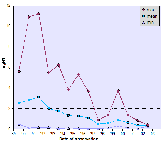
What's on the graph?
The graph shows how ammonia data for this river section has changed over time.
Table of Ammonia
| Date of observation | centile10 (mgN/l) | centile50 (mgN/l) | centile90 (mgN/l) | count | max (mgN/l) | mean (mgN/l) | min (mgN/l) |
|---|---|---|---|---|---|---|---|
| 10/1989 | 1.22 | 2.35 | 4.44 | 34 | 5.60 | 2.55 | 0.46 |
| 10/1990 | 0.58 | 1.98 | 5.76 | 48 | 10.90 | 2.80 | 0.13 |
| 10/1991 | 0.47 | 2.55 | 6.54 | 64 | 11.20 | 3.11 | 0.16 |
| 10/1992 | 0.50 | 1.40 | 4.79 | 53 | 5.48 | 2.01 | 0.17 |
| 10/1993 | 0.19 | 1.49 | 3.61 | 53 | 6.23 | 1.76 | 0.04 |
| 10/1994 | 0.25 | 1.18 | 2.63 | 47 | 3.83 | 1.31 | 0.09 |
| 10/1995 | 0.15 | 1.11 | 1.97 | 13 | 5.30 | 1.28 | 0.03 |
| 10/1996 | 0.12 | 0.47 | 2.24 | 11 | 3.68 | 1.08 | 0.04 |
| 10/1997 | 0.11 | 0.42 | 0.88 | 12 | 0.89 | 0.49 | 0.04 |
| 10/1998 | 0.15 | 0.51 | 1.17 | 13 | 1.36 | 0.56 | 0.10 |
| 10/1999 | 0.35 | 0.63 | 1.01 | 12 | 3.73 | 0.87 | 0.31 |
| 10/2000 | 0.17 | 0.50 | 1.22 | 12 | 1.35 | 0.62 | 0.13 |
| 10/2001 | 0.10 | 0.31 | 0.68 | 12 | 0.82 | 0.35 | 0.06 |
| 10/2002 | 0.28 | 0.38 | 0.39 | 3 | 0.39 | 0.34 | 0.26 |
What's in the table?
The table shows how ammonia data for this river section has changed over time.
Other options
- Back to WebSMURF river navigation page
- Start again at a new place on the river.