The SMURF System in detail
The full desktop SMURF System is an advanced Geographical Information System (GIS). It enables you to display land use and other river catchment-wide information on a basemap of the area. But the SMURF System is far more than just a display tool. For any planning decision involving a change of land use, you can use the SMURF System to determine what impact this will have on the surrounding river and drainage network.
In order to be able to answer these questions, the SMURF System uses a set of models, working on a whole host of data. This includes geographical data (e.g. land use), time series data (e.g. GQA Chemistry Grade over time) and derived data (e.g. SuDS suitability).
The advanced capabilities of the SMURF System mean it can provide the answers to vital 'what-if' planning questions. For example: 'What if we built a housing development on this site?'; or: 'What if we invested in upgrading the habitat of the river through the playing fields'. The answers to these 'what-if' questions can be displayed in a number of different ways to facilitate understanding and further work – e.g. on a map, as a graph or as raw data in a spreadsheet.
Data in the SMURF System
The SMURF System contains geographical data (e.g. land use), time series data (e.g. GQA Chemistry Grade over time) and derived data (e.g. SuDS suitability).
Key datasets used for modelling:
- GQA chemistry monitoring data
- GQA biology monitoring data
- Gauged flows and water levels
- Fisheries monitoring data
- Habitat scoring
- Land use
Example GIS layers included with the SMURF System (provided by the Environment Agency, Birmingham City Council and Severn Trent)
- Lakes
- Licensed abstraction point
- Discharge consent
- Active landfill sites
- Dangerous substances1
- Dangerous substances2
- Source protection zones
- Community forest
- County
- District
- Sites of importance for nature conservation
- Key local conservation sites
- National nature reserve
- Sites of special scientific interest
- Tree preservation order
- Conservation areas
- Wildlife action areas
- Statutorily Listed Buildings
- Locally Listed Buildings
- Scheduled Ancient Monument
- Historic parks and gardens
- Footpaths
- Regeneration areas
- Greenbelt
- Initiative area
Other data:
- Monitoring sites
- DTM
- SuDS suitability
- Photographs
SMURF System Models
The SMURF System uses models to answer 'what-if' questions such as 'What if we built a housing development on this site?'; or: 'What if we invested in upgrading the habitat of the river through the playing fields'.
In order to provide maximum flexibility, the SMURF System can use the following models:
- InfoWorksRS
- SIMCAT
- 'Unspecified' models – these are either simple, rules-based changes of the sort demonstrated on this CD-ROM or a user built model.
The models allow the impact of a change within the river catchment to be assessed in terms of changes to flows and water quality:
InfoWorksRS
The InfoWorksRS model provides the nodes (single points in space) and reaches (lengths of the river) used to build the river 'superset'. The superset links data from different sources to locations on the river network. This in turn allows the impact of changes in the river catchment (be they natural or man made) to be assessed in terms of flow and water quality.
SIMCAT
The SIMCAT model is a statistical water quality model used by the Environment Agency. It is mainly used to assess the impact of point discharges into the river. It has been included in the SMURF System to allow the impact of changes in the river catchment to be assessed in terms of the impact they have on water quality. View a PDF file showing the SIMCAT Schematic (Adobe® Reader® required. If you do not have this installed already, you can download Adobe Reader from the internet for free).
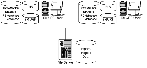
SMURF System Architecture
The SMURF System is an extension to the popular Geographical Information System ArcGIS. It is designed to be run on a standalone PC with ArcGIS installed.
The system architecture (as illustrated below) is such that the SMURF Systems tools, models, GIS and databases are on individual computers, but that data can be shared between users with an import and export facility.